about 3ft or 1 metre tall at shoulder
probably introduced by the Romans
(Part 3, Chapter 7, Section 1) ( Bk. Index )
Introduction
Imparking the Common
The Owners
The Occupiers
The House
Anecdotes of the Squire
The Park and Farm
In times past Michelgrove House had a deer park in Angmering. This park was not a manor in its own right, but such a complex web of several manors, that it must be considered all of a piece on its own.
In the wide open countryside of the 19th century hunts would roam far and wide, if not for the deer, then for the humble hare, providing sport for Victorian gentleman. One such hunt began near the coast, ending successfully for everyone other than the exhausted animal, after chasing it as far as Angmering Park.
1864 Major Gaisford’s Harriers:
The meet on Saturday last was at Roundstone near to Angmering and a very capital field mustered, before the commencement of the sport the gallant Major requested all to avoid as much as possible riding on the wheat plant. This considerate request was very cheerfully acceded to, & the harriers were put into a field close by at Kingston, but without finding.
Some half hour elapsed before the well known cry was given when a fine hare was turned up near Pigeon House Farm, which showed some unusually good sport. The field had now mustered pretty strong, including about 50 horsemen, and the gallant little pack led the way at full cry. Reaching the village of Preston for the moment the scent was lost, but puss being sighted near the Church, the beauties were soon on, & the cry was kept up merrily into the grounds of Captain Warren, at Preston Place, & thence over the line of railway at the Angmering station.
To the right of the line the smart little pack came upon the scent with full force & started off with speed somewhat unusual in hare hunting. Crossing a field or two brought us to Ham Park, and here all sped at clipping pace &. crossing Black Ditch which runs across the valley at the confines of the Park, in which one or two met with ‘purlers’ & away to the decoy & by New Place into Angmering Park. The pace was still kept up across Leather Bottle Lane to the Dover and thence into Michelgrove Woods. Here the hunting was confined for pretty much some time, the hounds leading the way cheerfully from one part of the woods to the other.
This hare was hunted for about an hour and it was eventually killed at the Decoy. Altogether it was one of the most clipping runs of the season. Those who saw puss describe her as being of unusual size.. a good finish to a capital days sport. [WSG]
The common man had to be more careful about what he hunted for the pot, even if his want was the greater. Two centuries earlier, three men from Warningcamp and Arundel were indicted:
“to answer certyne Riotts Routes and unlawful hunting in Angmering Parke and in the lands of William Palmer Esq “ [Bargham]. [SRS 54]
Many a man would sup at the great man’s table unbidden.
 |
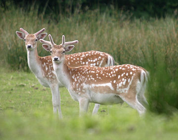
Fallow Deer about 3ft or 1 metre tall at shoulder probably introduced by the Romans |
There can be few people in Angmering and neighbourhood who do not know Angmering Park. That great landscape of woodland, pasture and arable, south of Barpham and north of the Arundel Road, A27. Only to newcomers may its identity be lost in the name Angmering Park Estates, owned by the Norfolk family. In the past it was a deer park attached to Michelgrove House , now a ruined remnant in Patching, but historically within a detached part of Clapham. Which leads on to the general subject of this history – the intricacies and ambiguities of ownership in the past, at least by manors and parishes.
It is no mere accident that placed Angmering on the coastal plain, and Barpham on the downs. In the distant past the downs provided security overlooking the coast, easy soils to cultivate, and extensive pastures could be created on which to graze flocks of sheep. On the coastal plain, heavier but fertile soils were a breadbasket for close knit settlements, Roman estates, and Saxon villages. In between was a belt of more intractable soils, best suited to woodland, an asset that providing timber, coppice, and swine pasture.
it is not to be wondered at that this woodland area was utilised by nearby settlements, with rights to pasture pigs as in Domesday, and only later was it found expedient to parcel out the land between the manors and parishes with defined boundaries. This did not prevent the Shelley family at Michelgrove from acquiring ownership, but in doing so many of the boundaries became blurred, especially those of the Angmering manors. As far back as 1679, in a survey of Angmering manors, no attempt was made to define boundaries in the park. In 1839, when the tithe maps were up, it was not manors that were being considered, but tithings inherited from that source, and it is clear enough that ancient boundaries had become largely confused.
<>
In 1614, John Caryll kt. died in ownership of the park, and his Inquisition Post Mortem contains the following interesting passage.
Capital messuage [house] called Angmeringe Howse and all that park or enclosed impounded land called Angmeringe Parke or le Downe Parke and lands etc., belonging to said capital messuage lying in Estangmeringe, West angmeringe, Eglesden, Rustington, Ferringe, Barpham, Preston, Patchinge, and Polinge held in chief. [SRS 33]
The Shelley park was the bulk of this area, but south of it straddling the modern A27, other parts of his estate probably had a similar Saxon origin.
As set out in 1839, the Poling and East Preston portions were south of the park. Rustington within the park and indeed included the house. Patching to the east side. Ferring, is a surprise, and there is no knowledge of any land or rights in the area. Barpham was defined when the map for Ham and Barpham was drawn up in 1847, with boundaries in the park towards the north and west sides. East and West Angmering, and Ecclesden, can only be surmised on the general basis of how the other areas were distributed. West Angmering a north south strip, between Rustington and Barpham. East Angmering, and Ecclesden, similar strips east of Rustington in the centre.
These neat strips are very odd, and smack of mere convenience. Nothing like that would have existed at Domesday. The nice straight east-west boundary of Barpham shown in the 1839 Angmering tithe map, was surely a convenience of the time.
In area, as surveyed in 1839. Poling occupied 138 acres in several plots north and east of New Place. Rustington 43 acres extending south from Angmering Park House. East Preston 16 acres south of Rustington, outside the impounded park. West Angmering the residue on the west of the park, and west of Park Lane. East Angmering and Ecclesden sharing a larger residue on the east side of the park.
The tithe apportionment for Angmering is decidedly confused. The map contains fields in the park that are scheduled with Ham and Bargham in 1847. But the Angmering schedule manages to omit one of those fields while including the others. That is to say the areas in 1847 added to the areas scheduled in 1839 are in excess of the true park area, but not to the extent of the Barpham share.
Poling in Angmering at Hammerpot
Part of the complex web of parishes in the north of Angmering south of the park. Including East Preston parish and manor outlier. Whether all the Poling parish outliers also belonged to the manor is not presently known.
It is notable that nothing appears to be known about the park, before the 15th century. Little enough until the 18th century, when the Tompkins Diary provides invaluable details about management of the Michelgrove estate from 1768 to 1814, at the end of the Shelley dynasty, and beginning of the Walker brief sojourn.
In summary it seems the park belonged to Shelley of Michelgrove, until 1511 when there is the usual unsubstantiated statement by Harris [Angmering a Study 1912] that John Palmer purchased it. As already mentioned John Caryll owned it later, and then his son after 1614, with the park later returning to Michelgrove ownership. On the decease of John Shelley it was soon afterwards sold to Richard Walker of Liverpool, in 1800. Then by Richard Watt Walker to the duke of Norfolk in 1827. The family still own this land, but the old Angmering House was replaced by the present building in 1982. [VCH]
With the park in various parishes, and the farm house there in a Rustington enclave, tracing tenants is something of a problem. Rustington probate inventories include a Park Keeper of 1631, Robert Lucas, and since there is no park in Rustington that could have warranted a keeper, it is fairly certain he was an employee of Shelley at Angmering Park. His house in the Rustington enclave.
Even more interestingly, there is an account book for the park, evidently kept by Thomas Leare who took over from Thomas Ashley as keeper in 1698. It contains receipts for wages of £8 a year, rising to £10 in 1700. Also various observations about the care of guns, game, and medication for his dogs, “A Recait to prevent madnes in dogs or ainey thing Els thatt is bitt by a mad dog.” A book which it would be well worth transcribing in full. [Add Mss 14915]
Thomas Ashley left a legacy of greater value, in charity for Rustington. It is rather odd how someone could live in the heart of Angmering, in the employ of Shelley of Michelgrove, and yet be a benefactor to Rustington because of a freak of history. In 1738 he left a fund for the poor to be distributed according to need. There are later accounts for this charity. [Par 164/1/1/4]
The Tompkins diaries do not appear to have a name for the park keeper or farmer, whatever title he may have had in the 18th century. There is a will of 1799 for John Hollands of Angmering Park, yeoman, but until this is read in detail it may be unwise to assume he lived at Angmering Park House, although it must be likely that he did farm the general area. [PROB 11/1322]
Then in 1815 a Keeper in the employment of Richard Walker was sent to Petworth House of Correction for some misdemeanour. The squire would have had several gamekeepers living in cottages around the park, there is no indication he was the head keeper. [PHA 10561]
It is after the park was taken over by Norfolk and from 1839 onwards that distinct references to the tenant can be found. George Olliver, described in the 1841 census as a farmer and aged 67. The family were of long standing in the district at Clapham and Angmering. But he died in 1842 suddenly ageing to 70 years old. Thomas Meetens took over the farm, and he was over 60, so the arrival of Robert Elliot a few years later is a matter of course. Followed in succession by John Mason and Thomas Peacock after the turn of the century. No doubt the list carries on at length but that is as far as this history need go.
There were also cottages serving the park, in the 19th century, but these are very difficult to place. Four households are named, typically with one shepherd a gamekeeper and labourers. This number increased in the 1901 census, with two gamekeepers and as many carters, together with a farm foreman.
An 1802 inventory of deer kept by Richard Walker has in bare total 649 animals listed, besides a black pony 13 hands high – all valued at £1330. Although the term ‘fallow deer’ is not used this is obvious from the breakdown. [Add Mss 16024]
The inventory was signed by William Woods, presumably the keeper at this time.
49 bucks in the fattening paddock
30 do park [Buck male fallow deer]
70 soars [Sore a buck of the fourth year]
20 soarals [Sorel a male fallow deer in third year]
100 prickets [A pricket is a male fallow deer in its second year]
100 fawns male [Fawn male in first year]
230 doe [Doe female fallow deer]
25 tegs [Teg a doe in second year]
25 fawns female [Fawn female in first year]
A sight to behold in the wide open spaces of Angmering Park. Petworth is a near equivalent today.
It is fairly certain there have been several houses in succession, occupied by Shelley park keepers and later by farmers on the Norfolk estate. In the 18th century and later, it was located at the northern extremity of the Rustington enclave, in the heart of the park. The first known of these being the typical medium sized farmstead style building occupied by Robert Lucas.
His probate inventory of 1631, had all the normal furniture and implements to expected. Although a Park Keeper, he was also allowed to own a small stock of animals, probably making use of the croft and field adjoining the house. Five cows and a dozen sheep with their lambs, made a useful source of income and food to supplement his wages. A riding horse was an essential. With cash and obscure debts owed him amounting to £120, his funds far exceeded the value of goods at under £50.
The rooms in his house are difficult to reconstruct, but point to a small halled building in origin. Three chambers or bedrooms, over his kitchen hall, and buttery, with a bakehouse and milkhouse attached.
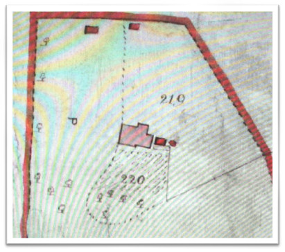
At what point this building was replaced is impossible to say. The 1839 map has a small unidentifiable house shown, that might have been the same or a new building. Certainly a photograph of the Lodge in 1954, is of a typical Norfolk designed dwelling. Two storey, brick, with tile hanging and tiled roof, with a bay window. In 1901 new cottages and houses were being built by Heveringham, clerk of works for Norfolk, at Lyminster and Old Place in Angmering, and the Lodge may well have been of that period. The mansion built in 1982 is to the east of the Lodge site.
 |
Angmering Lodge in 1839 Farm buildings were to the right as later. The red line marks the Rustington parish boundary of this enclave. |
The coachmen who drove the extra coaches during the season were [several names] and Philip Butcher. The last named they used to call “Little Phil.” He was a very smart coachman, and could handle the whip and ribbons in a very businesslike manner. They used to say he could take a fly off the leaders’ ear with his whip, although I never saw him do it. He was a great favourite with Mr Richard Walker of Michelgrove.
Squire Walker, as he was called, had a fine mansion at Michelgrove. He was fond of all kinds of sport; something like the late Marquis of Waterford, or the sporting Jack Mytton. The Squire kept a large stud of hunters and racehorses. On one occasion he sent a letter to his stud groom in London, telling him to take one of the horses named Rollin to Mr Tattersall’s, at Hyde Park Corner, to be sold by auction. The groom read the letter wrong, and sent in Robin, a very valuable animal. The horse was sold very cheap.
Shortly afterwards the Squire went to town and in going into the stables, enquired after Robin. “Robin, sir,” said the groom, “Why, you sent word for him to be sold.” “Oh no,” exclaimed the Squire “nothing of the kind. I told you to sell Rollin. Why, I wouldn’t take any money for Robin.” The Squire was terribly vexed at the mistake and enquired if the groom knew who bought the horse. “Yes sir,” the man replied, “ Mr George Cross, the Littlehampton coach-proprietor, has got him.” This somewhat pacified Mr Walker who made sure that he could get his horse back again, and he immediately went to Littlehampton, and meeting Cross, asked him, “Mr Cross, I hear you have bought my horse at Tattersall’s.” “Yes, Squire, I did,” replied Cross. “Well,” says the Squire, “I must have him back again. I did not mean my groom to sell him.” “Oh, you can’t have him, sir,” says Cross very decidedly. “What,” shouts the Squire in a towering rage, “can’t have my horse back again! Well then, --- me if I don’t ruin you!”
The Squire started coaches from Littlehampton to London in opposition to Mr Cross. The usual coaches from Littlehampton to London used to run through Arundel, down Bury Hill, through Pulborough and Billingshurst, to join the Worthing Road at Bear Green. Mr Walker went to the expense of making the road by Long Furlong, out by the kennels at Findon - a shorter cut - so that he could get his coaches to London in less time than Mr Cross could get his. He got attractive matched teams together, four blacks, four greys, and so on, but he could only get three piebalds, so to complete the team he bought a white grey and had him painted to match the others.
Little Phil Butcher was the first coachman, and a great favourite too. He just suited the Squire. He could drive a coach or ride a race with any man you could find in those days. But the Squire did not ruin Mr Cross, who stuck to the road until the iron horse drove him off. It was the Squire himself who was ruined. He came utterly to grief, and had to sell his mansion and beautiful park to the present Duke of Norfolk’s great-grandfather, who had the house pulled down and turned the park into farms. The old clock tower stands on the hill now, but the clock was given to Steyning, and it is in the High Street at the present time.
Maps are invaluable in local history, but the earliest at hand showing Angmering Park in any detail is the Sussex map of c1780. Just within the Shelley era, when it was in full flush as a deer park, and a count in 1802 gave a figure of 649. [Add Mss 16024]
In 1780 the park was firmly delineated, the farmstead set centrally within grassland studded with standard trees. Small areas of woodland to the perimeter, excluding the south side. A lane north from Dover at the south end marking the west boundary, and another lane from Swillage to the east. At the time it was reckoned to cover 660 acres.
The 1679 Angmering survey does include an entry for Sir Charles Shelley Bart. mainly because he owned New and Old Place farms and owed a nominal freehold rent for these. He also had a ‘major part of Angmering Park’ belonging to West Angmering manor, but with estimate of area ventured. Quite separately, he paid 8s 6d freehold rent for Smiths Wood in the park.
John Tompkins was estate agent to Shelley at this time, and within the general comments in his diary about Michelgrove can be discerned some few items directly concerning the park. The pigeon house at Michelgrove was very productive, and there are comments about dozens of these being sent to various residences of the family. On one occasion in 1768 some sent to the servants, and sixteen to Dover and the park – farmhouse.
Later the same year, “the old Carthorse in the Coach Team formerly bought of Tho Lear was had up to the park for Dogs meat he being so worn out that he does not earn his meals.” A pack of foxhounds was kept at the farm as mentioned by James Town in his reminiscences quoted.
There are numerous notes about felling of trees in the estate, but also of considerable replanting. Large quantities of beech saplings being bought from James Newman at Lyminster, and Arundel. “300 young Beech trees that were bedded there for the same price as the last & carried to the new large plantation above the pond in the park.” [Add Mss 12091]
When the Duke bought out Richard Walker in 1800, for £110,000, the mansion was demolished together with much that may have been of interest historically to Angmering. But if the 1780 map is at all accurate, and it is on the whole, there ensued a large scale felling of woodland. By 1839 tree cover had shrunk dramatically, so that only two or three small woods remained. A large part of the park was now arable, on the eastern side, and no doubt deer were not encouraged. When Thomas Meetens had the tenancy it was reckoned it amounted to almost 500 acres. His successor Elliott, had the services of nine men and four boys.
 |
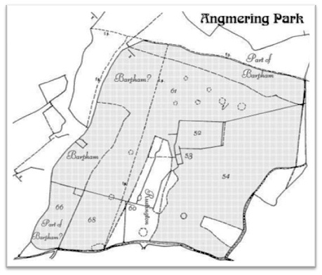
Angmering Tithe map 1839 George Olliver farm at Angmering Park |
Rustington parish enclave in 1839
This included the farmstead at the north end of the area marked Rustington
45 acres
Duke of Norfolk land in hand
This comprised two small woods at the lower corners of the park, and small plantations in the park.
57 8.65000 wood Seldon Corner Beeches
58 0.25625 wood Plantation
59 3.09375 wood Plantation
67 2.26250 wood Plantation
Total 14.2625
Duke of Norfolk owner
George Olliver tenant
Areas in acres
52 16.1688 grass Paddock
53 1.3813 house Park Farm Buildings Yards etc
54 156.1063 arable Velvet Hill Field & Selden Corner Field
60 0.0813 arable Part of Rustington Bottom
61 170.7375 grass Part of Angmering Park
66 26.1250 grass Dover Field
68 35.0875 grass Butlers Piece
TOTAL 405.6875
Grand Total 464.95 acres with Rustington
But it is evident that a field on the west side of the park is not included, perhaps another 40 acres.
The park was therefore over 500 acres by this measure.
 |
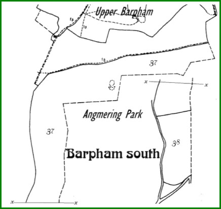
Barpham Map 1849 with revised areas |
Bargham (Upper Barpham) schedule 1849
37 (nil) Part of Park
38 (nil) Part of Park
TOTAL 154 acres
It can be seen from this map that the area assigned to Barpham is quite unilike any area delineated on the 1839 Angmering map. It extends down the side of the park as far as the Dover and above Priorslease farm. It also includes a wide strip across the north of the park.
Fortunately the 1876 Ordnance Survey maps have accurate areas for enclosures scheduled. It does not pay attention to archaic manors and is not helpful in that regard.
If all its minutae are added together an even larger total than 500 acres is calculated. In the order of 550 acres, although this probably includes strips of land and roads not in the tithe area.
There are sources of information not yet consulted. Some few maps and other items in the Norfolk archives.
References:
As noted in the text and almost entirely Mss, Maps, and items at WSRO
Also Victoria County History
RWS 16.12.08 NRD